Not long ago, I was involved in a discussion about how much more the British seem to know about American history than Americans know about British history, particularly contemporary events. Whether or not that’s true, it made me think of some surprises I had in England, and what I learned about British history that I never heard in school.
If you follow my blogs, you know I like to write about the unusual; things which don’t seem to be common knowledge among my peers. I’m not super interested in knowing what someone is cooking for dinner or what happened on the way to the kid’s soccer practice, and I'm not going there.
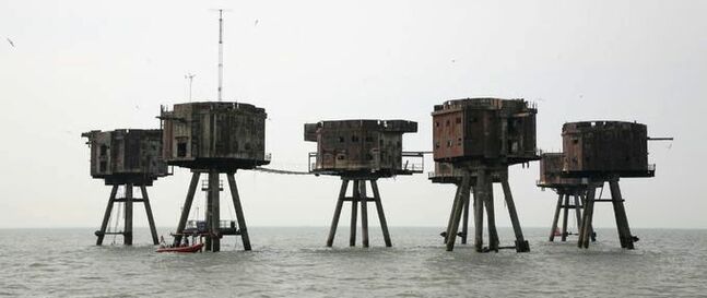
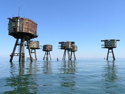
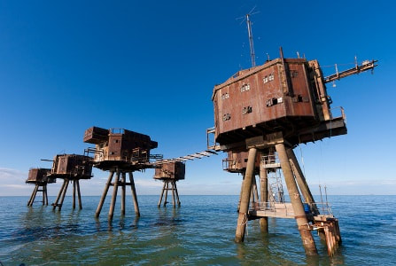
What I want to know is who built these towers in the ocean and why? And why have they been left to fall into ruin?
If you follow my blogs, you know I like to write about the unusual; things which don’t seem to be common knowledge among my peers. I’m not super interested in knowing what someone is cooking for dinner or what happened on the way to the kid’s soccer practice, and I'm not going there.
What I want to know is who built these towers in the ocean and why? And why have they been left to fall into ruin?
THE MAUNSELL SEA FORTS: A SHORT BUT BUSY LIFE
No, this has nothing to do with Venus, although this does appear other-worldly, like something out of Star Wars.
These bizarre-looking structures were erected off shore on the Thames estuary, England, and were named after the civil engineer who designed them, Guy Maunsell. They were born in the early 1940s during WWII as part of the United Kingdom’s defenses. They were operated by the British army and navy and, having served their purpose, were decommissioned in 1958, abandoned in the early 1960's, and left to die a slow, lonesome death surrounded by the North Sea. A few were destroyed in collisions with ships. Of the original seven, only three survive. Although most of the actual forts may be gone but the design of contemporary oil platforms is largely based on Maunsell’s ingenuity.
Two types of fort – army and navy -- were built on the coast and moved, virtually intact, to carefully chosen spots guaranteed to provide maximum protection. Innovative in concept and design, they were also heavily armed.
Shivering Sands Army Fort - Photo source: Red Sands Army Fort - Photo source: Locations of the seven Maunsell Forts - Photo source
en.wikipedia.org/wiki/Shivering_Sands_Army_Fort gizmodo.com/exploring-abandoned-sea-forts en.wikipedia.org/wiki/Maunsell_Forts
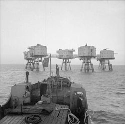
NAVAL FORTS
Four naval-style forts, operated by the Royal Navy -- named Rough Sands, Sunk Head, Tongue Sands, and Knock John – were placed off-shore near the Thames Estuary. The intent was to guard against bombers, report German air raids, and prevent enemy aircraft laying mines in this vital shipping channel. Picture credit: http://harwich-society.co.uk/old/info_rough_towers.htm
Photo source: web.archive.org/web/20140818011956/harwich-society.co.uk
en.wikipedia.org/wiki/Shivering_Sands_Army_Fort gizmodo.com/exploring-abandoned-sea-forts en.wikipedia.org/wiki/Maunsell_Forts
NAVAL FORTS
Four naval-style forts, operated by the Royal Navy -- named Rough Sands, Sunk Head, Tongue Sands, and Knock John – were placed off-shore near the Thames Estuary. The intent was to guard against bombers, report German air raids, and prevent enemy aircraft laying mines in this vital shipping channel. Picture credit: http://harwich-society.co.uk/old/info_rough_towers.htm
Photo source: web.archive.org/web/20140818011956/harwich-society.co.uk
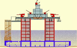
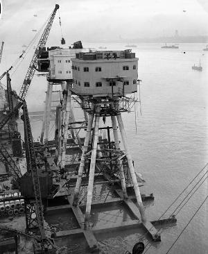
The platform base of a naval station was fixed to the sea bed and consisted of a 168’ by 88’ platform for a superstructure 60 feet tall. The pontoon base supports two giant pillars 24’ high. Each pillar had seven floors for crew housing, dining, operational areas, storage for fresh water, generators, and munitions.
The towers were joined above the waterline by a steel platform which sustained living spaces, officers’ quarters, galley, medical office, and a gun/radar tower. Supplies were lifted from ships onto a steel landing platform by a crane. Knock John Fort was manned by around 100 men and was self sufficient for a month. The platform base of a naval station was fixed to the sea bed and consisted of a 168’ by 88’ platform for a superstructure 60 feet tall. The pontoon base is supports two giant pillars 24’ high.
Each pillar had seven floors for crew housing, dining, operational areas, storage for fresh water, generators, and munitions.The towers were joined above the waterline by a steel platform which sustained living spaces, officers’ quarters, galley, medical office, and a gun/radar tower. Supplies were lifted from ships onto a steel landing platform by a crane. Knock John Fort was manned by around 100 men and was self sufficient for a month.
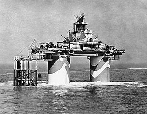

Naval style Fort - Photo source: Fort Tongue 1992 – Totally collapsed in 1996 all that remains is a single 18 foot stump
en.wikipedia.org/wiki/Maunsell_Forts of the Southern - Photo source: /www.bobleroi.co.uk/ScrapBook/
en.wikipedia.org/wiki/Maunsell_Forts of the Southern - Photo source: /www.bobleroi.co.uk/ScrapBook/
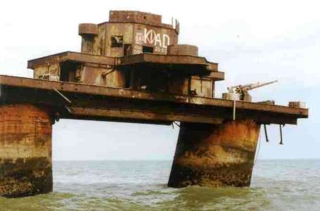
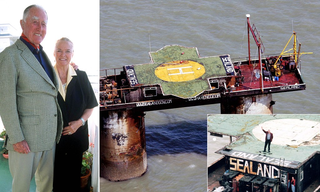
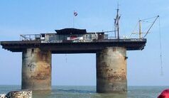 | 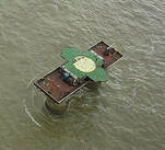 One of the survivors, Fort Roughs [photos right], was taken over in 1967 by Paddy Roy Bates and his family [by ousting a pirate radio station], and self-proclaiming it as an independent nation. |
tos: https://en.wikipedia.org/wiki/Principality_of_Sealand Ryan Lackey - originally posted to Flickr as sealand-sky Link to License:
en.wikipedia.org/wiki/Principality_of_Sealand en.wikipedia.org/wiki/Principality_of_Sealand
Although Bates tried to have the Principality of Sealand recognized officially and legally, it is not accepted by anybody and legally lies within the territorial waters of the United Kingdom. Bates later moved to Suffolk, and in 2012, before he died at 91, he named his son as regent. The statement about the legal status on the site is as follows.
“The forts were abandoned in the early 1950’s and, due to their illegal construction in international waters in a time of world crisis, they should been destroyed to comply with international law. Except for the aforementioned fortress [Fort Roughs], similarly located fortresses were subsequently pulled down. The result of this was the portentous uniqueness of the fortress. Fort Roughs Tower, situated on the high seas, had been deserted and abandoned, res derelicta and terra nullius. From a legal point of view, it therefore constituted extra-national territory.” https://www.sealandgov.org/
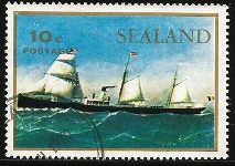
The Principality of Sealand has a website, and at the online gift shop you one purchase Sealand stamps, passport, T-shirts … even a knighthood.
en.wikipedia.org/wiki/Principality_of_Sealand en.wikipedia.org/wiki/Principality_of_Sealand
Although Bates tried to have the Principality of Sealand recognized officially and legally, it is not accepted by anybody and legally lies within the territorial waters of the United Kingdom. Bates later moved to Suffolk, and in 2012, before he died at 91, he named his son as regent. The statement about the legal status on the site is as follows.
“The forts were abandoned in the early 1950’s and, due to their illegal construction in international waters in a time of world crisis, they should been destroyed to comply with international law. Except for the aforementioned fortress [Fort Roughs], similarly located fortresses were subsequently pulled down. The result of this was the portentous uniqueness of the fortress. Fort Roughs Tower, situated on the high seas, had been deserted and abandoned, res derelicta and terra nullius. From a legal point of view, it therefore constituted extra-national territory.” https://www.sealandgov.org/
The Principality of Sealand has a website, and at the online gift shop you one purchase Sealand stamps, passport, T-shirts … even a knighthood.


ARMY FORTS
The Army forts had a more complicated design, comprising separate platforms linked by catwalks and carrying more guns than their naval counterparts. Each fort consisted of a central control tower linked to six satellites. The thirty fot towers took eight weeks to build but could be put in position in less than eight hours.
The Army forts had a more complicated design, comprising separate platforms linked by catwalks and carrying more guns than their naval counterparts. Each fort consisted of a central control tower linked to six satellites. The thirty fot towers took eight weeks to build but could be put in position in less than eight hours.

Army Style Fort when in use Forts under construction on shore Alignment of Army Fort
en.wikipedia.org/wiki/Maunsell_Forts Public Domain www.bobleroi.co.uk/TongueTower/
en.wikipedia.org/wiki/Maunsell_Forts Public Domain www.bobleroi.co.uk/TongueTower/
The Red Sands army fort is made up of seven forts that were linked by walkways. There is an on-going effort to restore the Red Sands army forts because they are considered to be in the best condition. During its short life, Red Sands shot down 22 Nazi warplanes, more than 30 V1 flying bombs, and sunk one submarine. Later, in the 1960‘s pirate radio stations operated from the Fort, “transmitting pop hits deemed too risqué for Britain's then-monopoly broadcaster the BBC.” Peter Shadbolt, for CNN
WHERE HAVE ALL THE TOURISTS GONE?
In the early 2000’s a consortium called Project Redsands was planning to conserve the fort situated at Red Sands. In the summers of 2007 and 2008 Red Sands Radio, a station commemorating the pirate radio stations of the 1960s, operated from the Red Sands fort on 28-day Restricted Service Licenses. The fort was subsequently declared unsafe, and Red Sands Radio has moved its operations ashore.
Photo source: http://x-pilot.co.uk/supporting-project-redsand/

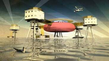
In 2015 there was a serious proposal to turn the towers into a luxury hotel. The forts themselves have no owners but Crown Estates – which manages all land under the control of the British sovereign – owns the seabed and any construction would require their permission.
Alan Harmer, part of Project Redsands, the registered charity that maintains the site, said interest for charter tours of the forts from German and Japanese tourists was particularly strong. "We've always had ideas to turn it into some type of accommodation and while this latest proposal seems a bit extreme -- I'm not sure it will turn out exactly as proposed -- it's always been something we've had on the cards. It seems the world is interested in these forts." www.cnn.com/travel/article/red-sands-sea-forts
As far as I could find out, four years later, nothing has happened.□
Photo Courtesy Aros Architects, London
Source: www.cnn.com/travel/article/red-sands-sea-forts
Sources:
http://www.culture24.org.uk/history-and-heritage/military-history/world-war-two/art528082-hotel-plan-could-save-world-war-two-redsand-forts-off-kent-coast
https://en.wikipedia.org/wiki/Maunsell_Forts
https://explorethearchive.com/maunsell-sea-forts
https://en.wikipedia.org/wiki/Principality_of_Sealand
https://maunsellseaforts.com/
https://en.wikipedia.org/wiki/Principality_of_Sealand
https://russ.garrett.co.uk/2011/08/21/red-sands-sea-fort/
https://en.wikipedia.org/wiki/Shivering_Sands_Army_Fort
https://twistedsifter.com/2012/10/maunsell-sea-forts-and-towers-wwii/
http://www.bobleroi.co.uk/ScrapBook/TongueTower/TongueTower.html
http://gizmodo.com/exploring-the-amazing-abandoned-sea-forts-of-world-war-512874771
http://www.gulbekian.plus.com/knockjohnhistory.html
https://www.sealandgov.org/
https://www.discoveringbritain.org/activities/east-of-england/aerial-2/britain-from-the-air-redsands-sea-fort.html
Photos:https://en.wikipedia.org/wiki/Maunsell_Forts#/media/File:The_Royal_Navy_during_the_Second_World_War_A26878.jpg
ontheworldmap.com/north-sea/
https://en.wikipedia.org/wiki/Maunsell_Forts#/media/File:Fortlocations.gif
Royal Navy official photographer - http://media.iwm.org.uk/iwm/mediaLib//31/media-31026/large.jpg This is photograph A 26878 from the collections of the Imperial War Museums
https://www.youtube.com/watch?v=vIYNJ3Lwftg
https://en.wikipedia.org/wiki/Principality_of_Sealand#/media/File:Sealand-sky_(cropped).jpg
http://www.bobleroi.co.uk/ScrapBook/TongueTower/TongueTower.html
https://commons.wikimedia.org/wiki/File:The_Royal_Navy_during_the_Second_World_War_A13259.jpg
http://harwich-society.co.uk/old/info_rough_towers.htm
Sources:
http://www.culture24.org.uk/history-and-heritage/military-history/world-war-two/art528082-hotel-plan-could-save-world-war-two-redsand-forts-off-kent-coast
https://en.wikipedia.org/wiki/Maunsell_Forts
https://explorethearchive.com/maunsell-sea-forts
https://en.wikipedia.org/wiki/Principality_of_Sealand
http://www.bobleroi.co.uk/ScrapBook/TongueTower/TongueTower.html
https://maunsellseaforts.com/
https://russ.garrett.co.uk/2011/08/21/red-sands-sea-fort/
http://gizmodo.com/exploring-the-amazing-abandoned-sea-forts-of-world-war-512874771
https://en.wikipedia.org/wiki/Principality_of_Sealand
https://en.wikipedia.org/wiki/Shivering_Sands_Army_Fort
https://twistedsifter.com/2012/10/maunsell-sea-forts-and-towers-wwii/
Photos
https://en.wikipedia.org/wiki/Maunsell_Forts#/media/File:The_Royal_Navy_during_the_Second_World_War_A26878.jpg
ontheworldmap.com/north-sea/
https://en.wikipedia.org/wiki/Maunsell_Forts#/media/File:Fortlocations.gif
Royal Navy official photographer - http://media.iwm.org.uk/iwm/mediaLib//31/media-31026/large.jpg This is photograph A 26878 from the collections of the Imperial War Museums
https://www.youtube.com/watch?v=vIYNJ3Lwftg
https://en.wikipedia.org/wiki/Principality_of_Sealand#/media/File:Sealand-sky_(cropped).jpg
http://www.bobleroi.co.uk/ScrapBook/TongueTower/TongueTower.html
https://commons.wikimedia.org/wiki/File:The_Royal_Navy_during_the_Second_World_War_A13259.jpg
http://www.culture24.org.uk/history-and-heritage/military-history/world-war-two/art528082-hotel-plan-could-save-world-war-two-redsand-forts-off-kent-coast
https://en.wikipedia.org/wiki/Maunsell_Forts
https://explorethearchive.com/maunsell-sea-forts
https://en.wikipedia.org/wiki/Principality_of_Sealand
https://maunsellseaforts.com/
https://en.wikipedia.org/wiki/Principality_of_Sealand
https://russ.garrett.co.uk/2011/08/21/red-sands-sea-fort/
https://en.wikipedia.org/wiki/Shivering_Sands_Army_Fort
https://twistedsifter.com/2012/10/maunsell-sea-forts-and-towers-wwii/
http://www.bobleroi.co.uk/ScrapBook/TongueTower/TongueTower.html
http://gizmodo.com/exploring-the-amazing-abandoned-sea-forts-of-world-war-512874771
http://www.gulbekian.plus.com/knockjohnhistory.html
https://www.sealandgov.org/
https://www.discoveringbritain.org/activities/east-of-england/aerial-2/britain-from-the-air-redsands-sea-fort.html
Photos:https://en.wikipedia.org/wiki/Maunsell_Forts#/media/File:The_Royal_Navy_during_the_Second_World_War_A26878.jpg
ontheworldmap.com/north-sea/
https://en.wikipedia.org/wiki/Maunsell_Forts#/media/File:Fortlocations.gif
Royal Navy official photographer - http://media.iwm.org.uk/iwm/mediaLib//31/media-31026/large.jpg This is photograph A 26878 from the collections of the Imperial War Museums
https://www.youtube.com/watch?v=vIYNJ3Lwftg
https://en.wikipedia.org/wiki/Principality_of_Sealand#/media/File:Sealand-sky_(cropped).jpg
http://www.bobleroi.co.uk/ScrapBook/TongueTower/TongueTower.html
https://commons.wikimedia.org/wiki/File:The_Royal_Navy_during_the_Second_World_War_A13259.jpg
http://harwich-society.co.uk/old/info_rough_towers.htm
Sources:
http://www.culture24.org.uk/history-and-heritage/military-history/world-war-two/art528082-hotel-plan-could-save-world-war-two-redsand-forts-off-kent-coast
https://en.wikipedia.org/wiki/Maunsell_Forts
https://explorethearchive.com/maunsell-sea-forts
https://en.wikipedia.org/wiki/Principality_of_Sealand
http://www.bobleroi.co.uk/ScrapBook/TongueTower/TongueTower.html
https://maunsellseaforts.com/
https://russ.garrett.co.uk/2011/08/21/red-sands-sea-fort/
http://gizmodo.com/exploring-the-amazing-abandoned-sea-forts-of-world-war-512874771
https://en.wikipedia.org/wiki/Principality_of_Sealand
https://en.wikipedia.org/wiki/Shivering_Sands_Army_Fort
https://twistedsifter.com/2012/10/maunsell-sea-forts-and-towers-wwii/
Photos
https://en.wikipedia.org/wiki/Maunsell_Forts#/media/File:The_Royal_Navy_during_the_Second_World_War_A26878.jpg
ontheworldmap.com/north-sea/
https://en.wikipedia.org/wiki/Maunsell_Forts#/media/File:Fortlocations.gif
Royal Navy official photographer - http://media.iwm.org.uk/iwm/mediaLib//31/media-31026/large.jpg This is photograph A 26878 from the collections of the Imperial War Museums
https://www.youtube.com/watch?v=vIYNJ3Lwftg
https://en.wikipedia.org/wiki/Principality_of_Sealand#/media/File:Sealand-sky_(cropped).jpg
http://www.bobleroi.co.uk/ScrapBook/TongueTower/TongueTower.html
https://commons.wikimedia.org/wiki/File:The_Royal_Navy_during_the_Second_World_War_A13259.jpg
 RSS Feed
.jpg)